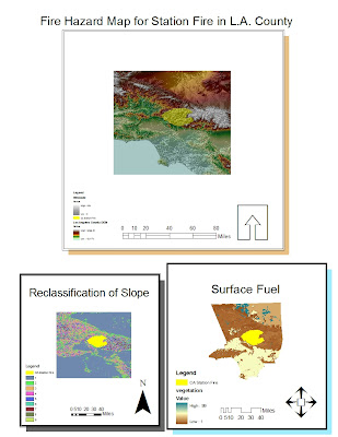
The map displayed above shows the fire perimeter of the station fire which happened in Los Angeles County in 2009. It is important to take into consideration all aspects which are related to the fire; these are slope, fire perimeter, and fire fuel. The slope of the terrain which the fire took place in is important because it gives information such as the direction the fire will burn and how fast it will burn (depending on the steepness of the slope). The fire perimeter provides information on the bounds and extent of the fire. The fire fuel, which is vegetation, can help determine where fire is more likely to burn and also what types of ecosystems will be affected by the fire.
This paragraph concerns more of the practical steps taken to produce the maps displayed. The seamless server from the USGS website was an easy way to obtain the digital elevation model for the county of Los Angeles. Once this was set, the FRAP website (http://frap.cdf.ca.gov/) was useful in providing surface fuels map as well as the fire perimeter data. This was the data needed to evaluate the fire hazard. It was easy to follow steps to accommodate the data to display the Station fire along with the DEM and hillshade. However, I encountered a problem with the reclassification of the surface fuel; this is why I only showed the original information for this individual map.
The problem I encountered had to do with the grid form of the surface fuel data and it made reclassification of this not possible. In order to fix this problem, I tried to download the data and start the process for this data set from scratch (I thought maybe the file was corrupted), but I still could not fix this issue. However, the surface fuel map shown, still provides a great deal of information in terms of fuel for the station fire. This is a map which informs about the bounds of the station fire, the slope of where it took place, and the surface fuel for the fire. Also, the scale bars, legends, and north arrows provide orientation to readers of the map.
No comments:
Post a Comment